Download de presentatie
De presentatie wordt gedownload. Even geduld aub

1
V AN H ALL I NSTITUUT Developments in GIS from data to work flow management Marinus de Bakker Expertise Centre Geo-information & Soil Management Van Hall Instituut, Groningen M.deBakker@pers.vhall.nl 13/10/03 University of Udine

2
V AN H ALL I NSTITUUT Contents as examples Riskmanagement & animal diseases t available data, knowledge and wisdom Parcel registration t project towards organisation Workflow management t GI in the enterprise

3
V AN H ALL I NSTITUUT GIS and animal diseases Foot and Mouth disease t Van Hall experiences Avian influenza t presentation Theoretical remarks

4
V AN H ALL I NSTITUUT Outbreak Foot and Mouth disease 11/04/01 Leeuwarden Groningen

5
V AN H ALL I NSTITUUT What to do? preventive measures need for specific data / information t students t home / practical placement t staff t animals? t communication t internal / external

6
V AN H ALL I NSTITUUT

7
Description of 2 km zone (example) The boundaries of the 2 km zone are as follows: 1. Vanaf H.M. Gerbrandywei N361 (Morra) volgend in noordoostelijke richting tot de 2 km cirkel Anjum. 2. De 2 km cirkel Anjum volgend met de klok mee tot Saatsenwei. 3. Saatsenwei de weg volgend in zuidwestelijk richting overgaand in Tibsterwei. 4. Tibsterwei volgend tot 2 km cirkel Ee. 5. De 2 km cirkel Ee volgend met de klok mee tot Lauwersseewei N361(Metslawier). 6. Lauwersseewei N361 (Metslawier) de weg volgend in noordoostelijke richting overgaand in H.M. Gerbrandywei N361 (Morra). ?? Usefull ??
 volgend in noordoostelijke richting tot de 2 km cirkel Anjum. 2. De 2 km cirkel Anjum volgend met de klok mee tot Saatsenwei. 3. Saatsenwei de weg volgend in zuidwestelijk richting overgaand in Tibsterwei. 4. Tibsterwei volgend tot 2 km cirkel Ee. 5. De 2 km cirkel Ee volgend met de klok mee tot Lauwersseewei N361(Metslawier). 6. Lauwersseewei N361 (Metslawier) de weg volgend in noordoostelijke richting overgaand in H.M. Gerbrandywei N361 (Morra). . Usefull .")
8
V AN H ALL I NSTITUUT Results foot and mouth difficult to get reliable data immediately crisis team afterwards ……….

9
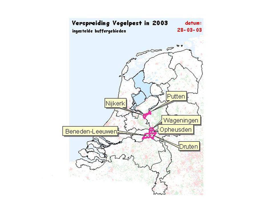
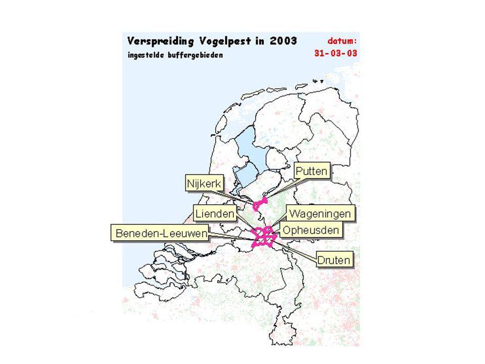
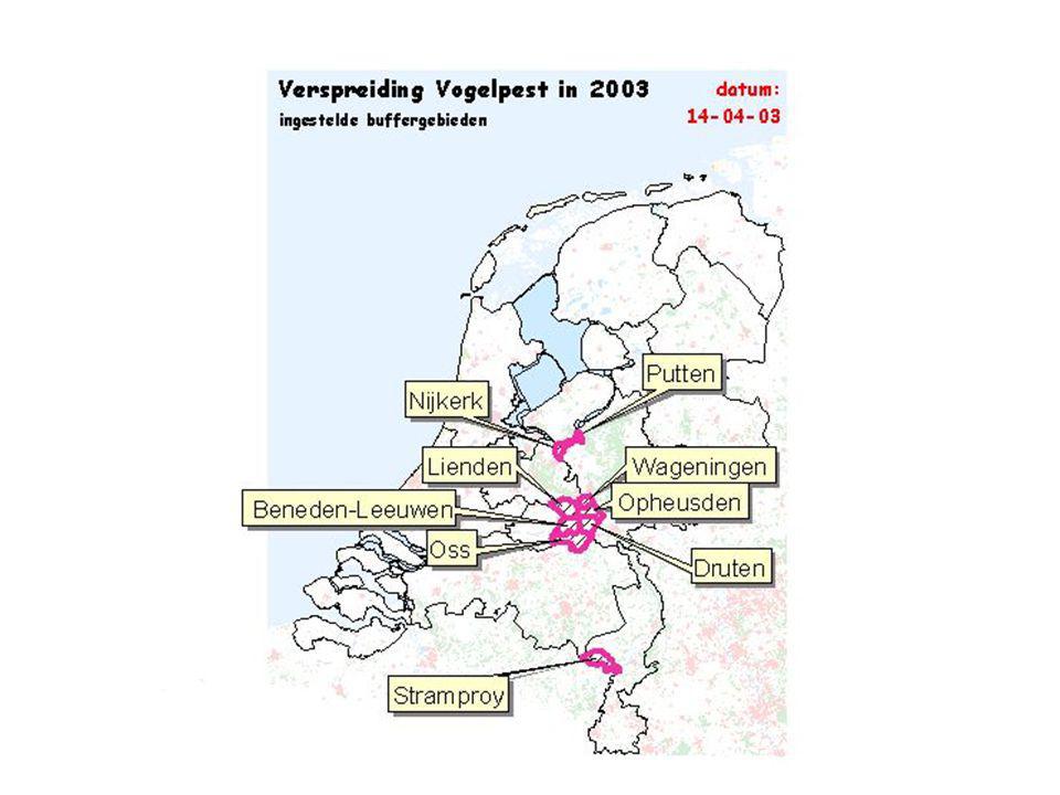
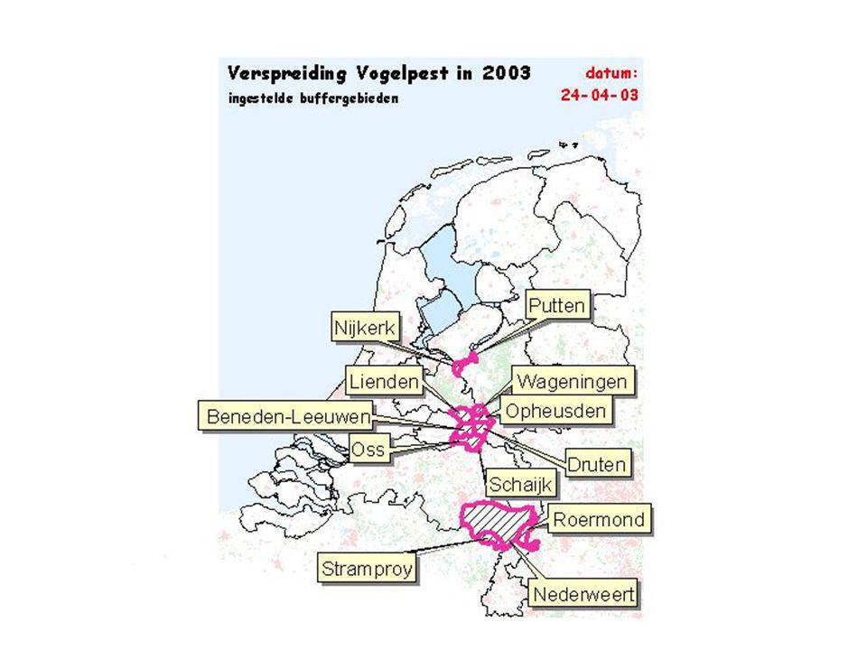
V AN H ALL I NSTITUUT Next crisis:Avian Influenza Ministry: t better prepared Slideshow: t weekly update of the different outbreaks t blue: suspect, red: confirmed t bufferzones: no transport

10
V AN H ALL I NSTITUUT Wekelijkse stand van zaken

11
V AN H ALL I NSTITUUT Wekelijkse stand van zaken

12
V AN H ALL I NSTITUUT Wekelijkse stand van zaken

13
V AN H ALL I NSTITUUT Wekelijkse stand van zaken

14
V AN H ALL I NSTITUUT Wekelijkse stand van zaken

15
V AN H ALL I NSTITUUT Wekelijkse stand van zaken

16
V AN H ALL I NSTITUUT Wekelijkse stand van zaken

17
V AN H ALL I NSTITUUT Wekelijkse stand van zaken

18
V AN H ALL I NSTITUUT Wekelijkse stand van zaken

19
V AN H ALL I NSTITUUT Wekelijkse stand van zaken

20
V AN H ALL I NSTITUUT Wekelijkse stand van zaken

21
V AN H ALL I NSTITUUT

29
Results Avian Influenza difficulty to get reliable data t location farms (postal codes) t professional farming versus hobby farming t up to date data redigitizing roads for blockades communication with the general public
 t professional farming versus hobby farming t up to date data redigitizing roads for blockades communication with the general public")
30
V AN H ALL I NSTITUUT Theoretical approach for the next “disaster” response Identification & Planning t risk assessment t collection of reliable and up to date consistent data t define the possible presentation Response t communication t short decisionlines Recovery t lessons for next year

31
V AN H ALL I NSTITUUT Conclusions Animal diseases exchange of t data (quality and structure) t information and organisation wisdom t prepare (GI team ready) t test (run simulations) t evaluate t learn & educate t stay prepared
 t information and organisation wisdom t prepare (GI team ready) t test (run simulations) t evaluate t learn & educate t stay prepared")
32
V AN H ALL I NSTITUUT From a project to an organization Government Service Parcel Registration, Ministry of Agriculture, Nature and Food Quality (DBR, Assen, the Netherlands)
")
33
V AN H ALL I NSTITUUT Parcel registration 1 need changed to several needs less administrative pressure / burocracy basic data: each farmer indicates his parcels t user, title, crop, date, area, coordinates, history t source, documents, communication t aerial photos, topographic and cadastral maps definition: t connected piece of land (no topographical boundaries) t used by 1 client, 1 user, 1 crop, 1 fertilizer number once collected (but update! every month) use for different measures / subsidies
 use for different measures / subsidies.")
34
V AN H ALL I NSTITUUT Actual procedure (< 1995) data Nature protection wildlife Nature protection vegetation fertilizers record verification decision calculate farmer as client account herbicides subsidy Each measure : rights
 data Nature protection wildlife Nature protection vegetation fertilizers record verification decision calculate farmer as client account herbicides subsidy Each measure : rights")
35
V AN H ALL I NSTITUUT problems different client numbers claims are too high / too low claims on 1 parcel by different clients parcels to difficult to digitize quality of digitized parcels was too low, time constraint!

36
V AN H ALL I NSTITUUT Data sources topographical data (1:10.000) arial photo’s cadastral map soil map municipality administration (name, adress) all digital farm map
 arial photo’s cadastral map soil map municipality administration (name, adress) all digital farm map")
37
V AN H ALL I NSTITUUT Unlink: collection and use data Record & verification decision calculate farmer as client account Each measure : rights

38
V AN H ALL I NSTITUUT Technical infrastructure databaseOracle 8ispatial / SDE operating systemVMS 7.3 interfaceDesigner/Developer 6.0 GISMap Objects 2.1

39
V AN H ALL I NSTITUUT Solution: long term data entry agricultural sector front office mid office back office services relationship parcels animal, plants

40
V AN H ALL I NSTITUUT Integrated organization model

41
V AN H ALL I NSTITUUT GI(S) integrates Work flow management
 integrates Work flow management")
42
GIS Implementation Cartography/Analysis Projects Personal GIS Departmental GIS EnterpriseGIS Data Access/Data Publishing Network/Cooperation Data Management

43
V AN H ALL I NSTITUUT Mindmap*.pdf

44
V AN H ALL I NSTITUUT Definition of workflow (I) number of activities to reach a goal (product or service) t logics and steps t personnel, materials (data), resources t tasks, responsibilities, qualifications, power t quality assurance of the procedure t link with time and money What to do by whom, when, and with what result?
 number of activities to reach a goal (product or service) t logics and steps t personnel, materials (data), resources t tasks, responsibilities, qualifications, power t quality assurance of the procedure t link with time and money What to do by whom, when, and with what result")
45
V AN H ALL I NSTITUUT Job Tracking for ArcGIS (JTX) enterprise workflow management application multi-user geodatabase environments simplifies, automates, tracking and streamlines workflow allocates resources Source: www.esri.com/jobtrackingwww.esri.com/jobtracking
 enterprise workflow management application multi-user geodatabase environments simplifies, automates, tracking and streamlines workflow allocates resources Source:")
46
V AN H ALL I NSTITUUT Definition of workflow (II) once versus repetitive t one map versus digital database t GIS procedure and/or GIS application research versus maintenance t explorative or confirmative (hypotheses) t collection of data and/or monitoring technical versus organizational content versus procedure
 once versus repetitive t one map versus digital database t GIS procedure and/or GIS application research versus maintenance t explorative or confirmative (hypotheses) t collection of data and/or monitoring technical versus organizational content versus procedure")
47
V AN H ALL I NSTITUUT Why a description of the workflow? analytical tool also use for communication t record t reproduce process objective, process design and process maintenance

48
V AN H ALL I NSTITUUT Focal point I have a GIS solution, where is the problem? I am involved in a workflow that could be enhanced, how can I use GI(S)? (effective and efficient)
. (effective and efficient).")
49
V AN H ALL I NSTITUUT Definition of workflow (III) level t individual t project t programme t division t enterprise wide t country wide t world wide
 level t individual t project t programme t division t enterprise wide t country wide t world wide")
50
V AN H ALL I NSTITUUT Project group level Source: http://www.rmsi.com/gis/processes.htm

51
V AN H ALL I NSTITUUT checklist how to use GI(S) in projects
 in projects")
52
V AN H ALL I NSTITUUT Approach (general + idealized) Level of project lifecycle Source: http://campus.esri.com
 Level of project lifecycle Source:")
53
V AN H ALL I NSTITUUT Knowledge management environment Working group project knowledge bank expertise circle calendar documents processes newsletter bring fetch

54
V AN H ALL I NSTITUUT Competences demonstrated abilities: behavioral characteristics that are important to fulfill a certain role /function with succes knowledge t GI infrastructure, - maintenance, - presentation, analysis, -visualise skills and attitudes t flexibility, communication, self-management, creativity t analytical capabilities, accuracy, compromise

55
V AN H ALL I NSTITUUT structure

56
Comparison competences / function

57
V AN H ALL I NSTITUUT levels 1. basic knowledge and attitude, coached, application in controlled environment 2. applies compentence independent in simple situations 3. more complex situations 4. applies competence in a flexible way, can help others

58
V AN H ALL I NSTITUUT Conclusion Communication creative innovative

59
V AN H ALL I NSTITUUT Questions? Discussion? Expertise Centre Geo-information & Soil Management Van Hall Instituut, Groningen M.deBakker@pers.vhall.nl

60
V AN H ALL I NSTITUUT (near) future update faster collection smarter t data input with internet (check?) t management info system of farmer (precision farming) t combination with other databases t 1 form for all presentation with internet (privacy?) later: include animals
 future update faster collection smarter t data input with internet (check ) t management info system of farmer (precision farming) t combination with other databases t 1 form for all presentation with internet (privacy ) later: include animals")
Verwante presentaties


![Deltion College Engels C1 Gesprekken voeren [Edu/002]/ subvaardigheid lezen thema: Order, order…. can-do : kan een bijeenkomst voorzitten © Anne Beeker.](/8/2048322/big_thumb.jpg "Deltion College Engels C1 Gesprekken voeren [Edu/002]/ subvaardigheid lezen thema: Order, order…. can-do : kan een bijeenkomst voorzitten © Anne Beeker.>")


